About us
KÉZDI_adapt group
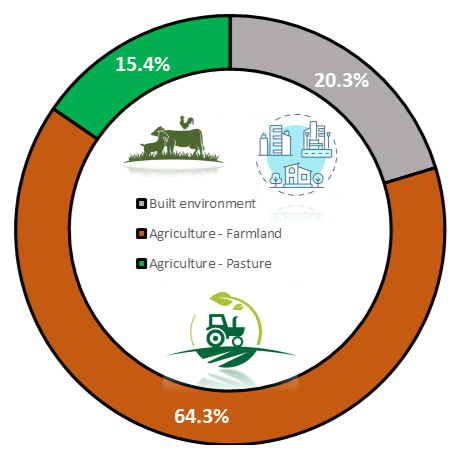
Târgu Secuiesc micro-region has a total area of 42.86 km2 from which 8.7 km2 (20%) is urban constructed area i.e. settlements, 27.55 km2 farmland used in crop production (64%) and 6.61 km2 (15%) pasture utilised in livestock sector. Thus 79% of the total area of the administrative unit is accounted for the agriculture sector having a significant impact on our society in many ways i.e. supports livelihoods through food, habitat, and jobs; provides raw materials for food and other products; and builds strong economies through trade, all these aspects are heavily depended on climate risk management and adaptation measures.
The livelihood of the population is located on 20% of the total administrative area, which can be directly affected by the major climate risks and not only. Local scale scenarios are requiring urban-relevant climate projections where alongside environmental hazard the socioeconomic impact must be assessed.
Some of the major climate-related risks that are considered to carry out using different workflows are as follow:
- agricultural drought – affecting agriculture, economic parameters i.e. ‘lost opportunity cost” for crops grown under non-irrigated conditions;
- river floods – flood damages, flood inundation map, damage curves etc.
- heatwaves – local scale scenarios even on small scale based on surface types (concrete, green area, asphalt etc.);
By scaling down the Climaax Framework and CRA Toolbox on our micro-region level, we will have the possibility to understand the risks and develop effective local risk management strategies to mitigate and adapt.

The results of the study

The results of the study would substantially help to cope with the major climate risks identified in our Sustainable Energy and Climate Action Plan (SECAP) as extreme heatwaves, droughts, river flooding events classified as emergency scale regarding intensity and frequency in our Municipality.
In the CRA Toolbox risk workflows are stratified by hazard profile therefore from a range of hazard types we could calculate on our administrative unit scale (micro-region) different expected damages, exposure, vulnerability, assets or population exposed to a specific hazard, as:
- impact of drought and heavy precipitation, flooding on agriculture and built environment;
- heatwave hot spots identification, localization in urban area, helping to identifying investments for mitigation;
- how green and blue infrastructure development can mitigate climate risks and how the expected agricultural output can be maintained and even increased;
- increase touristical potential and support local SME’s etc.