
PHASE 2
KÉZDI_Adapt: Agricultural drought
Climate hazard and risk analysis for Târgu Secuiesc
The KÉZDI_Adapt team investigated the hazard and risk assessment workflow for agricultural drought at the micro-regional level, covering Târgu Secuiesc municipality and Covasna County. Using the CLIMAAX Agricultural Drought workflow, the study analysed yield and revenue losses for potato, maize, wheat, and rapeseed due to agricultural drought under the RCP 4.5 climate scenario, comparing the near-future (2026–2030) and mid-century (2046–2050) periods. Phase 2 results highlight the local aspects of hazard and risk using downscaled variables, providing valuable support for developing regional and local risk assessment strategies.
Key Lessons Learned through PHASE 2 
i. Workflow design, spatial scale, and model selection are critical determinants of estimated drought impacts. This is clearly demonstrated by the micro-regional assessment of agricultural land in Covasna County using the CLIMAAX Agricultural Drought workflow, where drought impacts can be substantially over- or underestimated depending on methodological choices. Transparent, well-validated workflows such as CLIMAAX, combined with appropriate spatial resolutions and carefully selected climate model ensembles (particularly GCM–RCM combinations such as MPI-ESM-LR + RCA4), are essential for producing robust and credible assessments.
ii. Crop vulnerability patterns remain consistent across scales. Maize is consistently the most drought-sensitive crop, followed by potato, while wheat and rapeseed are generally the least affected. Incorporating local context, such as detailed crop calendars, season timing, and high-resolution data, enhances accuracy, smooths unrealistic extremes, and uncovers crop-specific risks that are hidden at larger scales.
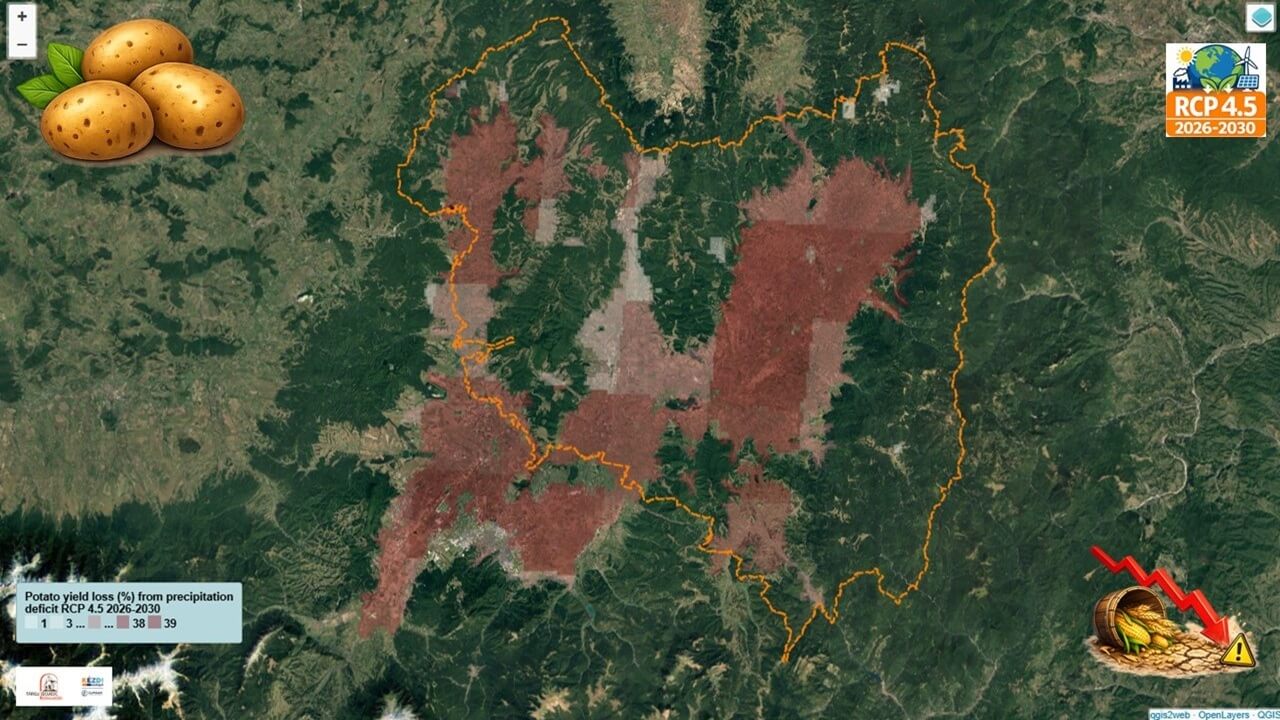

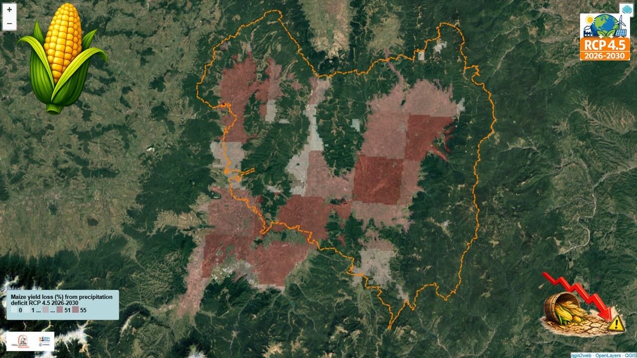

Figure 1. Yield loss maps using GIS data
iii. Water deficit represents a growing structural challenge. Persistent negative climatic water balance across scenarios (RCP 4.5 2026-2030 and 2046-2050) signals increasing water stress, even in wet/cooler regions, highlighting the need for improved irrigation and water management strategies.
Under RCP 4.5, the Climatic Water Balance (CWB = P – ET₀) shows a clear annual deficit of –259 mm during 2026–2030 and –137 mm during 2046–2050. Although the deficit narrows slightly in the later period due to higher precipitation, it remains significantly negative. This climatic shortfall translates into substantial crop-specific irrigation requirements. Average irrigation needs rise from 670 mm (2026–2030) to 747 mm (2046–2050) for potato – the most water-demanding crop – while maize increases modestly from 413 mm to 436 mm. Wheat and rapeseed show more stable but still considerable demands (around 300 mm and 240 mm respectively).
The difference between simple annual crop water balance (CWB) deficits and actual irrigation requirements arises because the detailed model incorporates crop-specific parameters calibrated to the local climate, including growing-season timing, growth-stage durations, crop coefficients (Kc), rooting depths, soil water depletion sensitivity, and yield response factors, together with the seasonal distribution of rainfall and evapotranspiration and effective rainfall. These results indicate that water deficits are likely to become a structural feature of future agricultural systems, underscoring the urgent need for advanced irrigation technologies, improved water-use efficiency, and adaptive water management strategies to sustain crop production under changing climate conditions.


Figure 2. Average ET0 and Precipitation RCP 4.5 for Near-future (2026-2030) vs. Mid-century (2046-2050) timescale


Figure 3. Irrigation requirements for the studied crops RCP 4.5 2026-2030
iv. Economic losses reflect these biophysical patterns with some adaptation signals. Maize dominates the economic risk, with projected near-future losses exceeding €1.38 million under RCP 4.5, although certain crops show declining impacts by mid-century, suggesting partial offsetting through adaptation or climatic shifts.


Figure 4. Revenue loss maps using GIS data
Key lessons learned:
1. Methodological Choices and Spatial Scale Strongly Influence Results:
Methodological choices, including climate model selection (particularly GCM–RCM combinations such as MPI-ESM-LR + RCA4), crop parameterization, and spatial resolution, strongly influence drought impact assessments. Regional-scale analyses tend to amplify estimated losses through spatial averaging, whereas local- and micro-regional assessments provide more realistic and robust estimates. Transparent, well-validated methodologies are essential for producing credible results.
2. Crop Vulnerability Patterns Require Local Calibration:
Maize is consistently the most drought-sensitive crop, followed by potato, whereas wheat and rapeseed generally exhibit greater resilience. Incorporating high-resolution local data including crop calendars, growth-stage durations, soil properties, and climate-specific crop parameters improves model accuracy and reveals crop-specific vulnerabilities that may remain hidden at coarser spatial scales.
3. Water Deficit Is Becoming a Structural Challenge
Persistent negative Climatic Water Balance (CWB) values indicate continuing water stress, even in relatively cool/ wet regions. Under the RCP 4.5 scenario:
- Annual CWB deficit: −259 mm (2026–2030) → −137 mm (2046–2050)
- Irrigation requirements: potato 670 → 747 mm; maize 413 → 436 mm; wheat ~300 mm; rapeseed ~240 mm.
Although the annual CWB deficit becomes less negative by mid-century, irrigation requirements remain high because water demand depends on seasonal rainfall distribution, evapotranspiration, crop phenology, and crop-specific characteristics. Detailed crop water modelling demonstrates that actual irrigation needs are substantially greater than those suggested by annual CWB alone, highlighting seasonal water stress as a growing structural challenge for future agriculture.
4. Economic Risks Mirror Biophysical Vulnerability
Maize accounts for the greatest projected economic losses (> €1.38 million under RCP 4.5). Lower impacts for some crops by mid-century suggest that climatic changes, adaptation measures, or both may partially offset future losses. Revenue loss patterns closely mirror crop yield vulnerability.
5. High-Resolution Assessments Support Effective Adaptation
Combining validated models with fine-scale local data provides more reliable information for crop selection, irrigation planning, and climate adaptation. Integrating hazard and risk assessments at the micro-regional scale is therefore essential for strengthening agricultural resilience and improving water management.
Main conclusion
Agricultural drought risk is spatially heterogeneous and cannot be adequately characterized using broad-scale metrics alone. Reliable and actionable assessments require local-scale, crop-specific analyses supported by rigorous methodologies. Such approaches are essential for developing realistic adaptation strategies that address both the biophysical impacts of water deficits and their associated economic consequences.
Our official page: https://climaax.kezdi.ro/
Our Facebook page: https://www.facebook.com/climaax.kezdi/
Our TikTok channel: https://www.tiktok.com/@climaax.kezdi?_r=1&_t=ZN-930jpgHBuQo